
UN Adopts New World Map After Africa Leads Push to Correct 450 Years of Distortion
The United Nations has voted to replace the Mercator map with the Equal Earth projection, a move that shrinks North America and Europe while giving Africa its true scale. Here's what changed, who pushed for it, and why it matters.
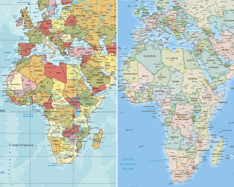
The United Nations General Assembly voted on Friday, September 4, to adopt a new official world map, one that finally reflects countries' true relative sizes instead of the distorted version the world has used for nearly 500 years. The resolution, known as "Correct the Map," passed with 164 countries voting in favour, six abstaining, and only the United States voting against it.
The map at the center of the change is called the Equal Earth projection, and it replaces the long-dominant Mercator projection, created by cartographer Gerardus Mercator all the way back in 1569. Mercator's map was built for a practical purpose, helping sailors navigate using straight compass lines, but it came with a major side effect: it drastically inflates the size of countries near the poles while shrinking those near the equator.
That means North America and Europe have appeared far larger than they actually are, while Africa, despite being big enough to fit the United States, China, India, and most of Europe inside its borders combined, has looked comparatively small on the map most of the world grew up with.
The resolution was introduced by Togo and backed by African Union member states along with the Bahamas, framing the change as correcting a "colonial-era injustice" that has shaped how the continent is perceived in classrooms, newsrooms, and policy circles for centuries. Moky Makura, executive director of the advocacy group Africa No Filter, which campaigned for the change, put it plainly: if the world got something as basic as Africa's actual size wrong for this long, it raises real questions about what else about the continent has simply been accepted without being questioned.
France, which co-sponsored the resolution, has already announced it will drop the Mercator map from official use. The countries that abstained from the vote were Ukraine, Estonia, Lithuania, Georgia, Moldova, and Serbia.
Passing the resolution is really just the starting point. The bigger challenge now is getting the Equal Earth projection into the places that actually shape how people see the world, meaning school textbooks, media outlets, government agencies, and the tech platforms billions of people check every day for directions and geography. That shift won't happen overnight, and old habits, plus decades of muscle memory built around the Mercator layout, mean plenty of institutions will likely be slow to update.
For a continent that has spent centuries being visually minimized on the very maps used to teach the world about itself, though, this vote marks a real shift, not just in cartography, but in whose scale finally gets counted accurately.

Stay rated, stay laughing.
Replies
0Sign in to join the thread.
- No replies yet.